Use of Pix4D: Photogrammetry and Drone Mapping

Weekly UAV surveys are carried out using a DJI Mavic 3E quadcopter type drone equipped with an RTK module. Together with ground control points, this allows an extremely accurate aerial survey to be carried out.
The site extents are programmed into the aircraft allowing it to generate a flight path which it automatically flies in around 10 minutes from take-off to landing. The aircraft remains under control and within sight of the GVC/A2CoC qualified pilot at all times. Once the flight is complete, the 290 photographs are uploaded to Pix4D cloud which converts them into a 2D orthophoto and a 3D model within a couple of hours.
The outputs can be shared with the site team who can then:
- View progress and compare to previous surveys
- Take measurements and volumes, the point cloud output is also shared with the earthworks contractor allowing him to check cut/fill volumes regularly
- Obtain as built coordinates of utilities
- Check perimeter fencing
- Monitor areas of the site where flooding can occur
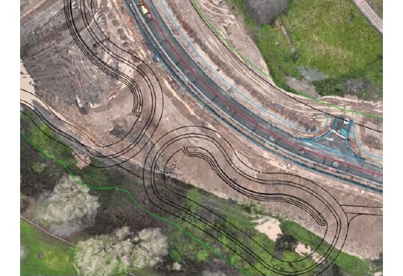
The overall orthophotograph can be printed out on the site plotter and used as a focus for site planning meetings. The Pix4D site can also be screen shared allowing it to be used for discussion during teams meetings The AutoCAD design has also been uploaded to Pix4Dcloud, this allows the as built survey to be compared visually, picking up obvious mistakes as early as possible
Footer Reference
Information provided by McLaughlin & Harvey Ltd
Did you find this article helpful?
Please rate this article
 (0 votes, average: 0.00 out of 5)
You need to be a registered member to rate this.
About this entry
About the author
Jack Endean
Partnerships and Innovations Manager
Entries by this author 1003
View all entries by Jack Endean
Company Information
Considerate Constructors Scheme
http://www.ccsbestpractice.org.uk
The Scheme does not promote or endorse any products, goods or services. For more information, click here.