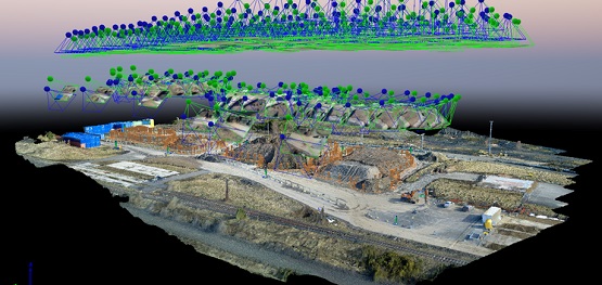
Sisk have employed an Ariel mapping company to continually monitor and quantify stockpile levels within a storage area used to hold good materials for use on future schemes.
Air hound are a new company offering services which are traditionally carried out by engineers which can be carried out by small aircraft safer and more efficiently and often more accurately than traditional methods.
Air hound use three different types of aircraft to carry out different tasks and can do a lot more than measurement of stockpiles for which they are currently employed.
Air hound currently overfly stockpiles of materials in a grid formation and take 300 gps points per second, these are then processed by the software to give an accurate measurement of the size (m3) of the heap. This can then be used to calculate the weights of different materials.
The drone pilots are all CAA qualified and insured and in fact the drones are programmed pre-flight so don’t require any operator input as they are fully automated.
These aircraft can also give ultra HD images for scheme photos, infra red imaging, thermal imaging as well as video for inspections.
Benefits include:
- Eliminates working at height risks on stockpiles
- Gives more accurate information due to the number of GPS fixes
- More efficient than engineers (less time required to survey)
- Releases engineers for other duties
- Cost comparable
- TripleView head
* 180° vertical range of motion
* 6x digital zoom
* Approx. 1 mm still image resolution at 5 m (16.4 ft) distance
* Active gimbal stabilisation
* Unobstructed field of view
* 38mp camera
Did you find this article helpful?
Please rate this article

Loading...


